

8 Hidden Waterfalls in Oregon: Quiet Cascades That Earn the Trip

Everybody knows Multnomah Falls. You've seen it on postcards, on calendars, and probably in three friends' vacation photos. It's gorgeous, and on most weekends it's also packed shoulder to shoulder.
But Oregon has hundreds of waterfalls, and a lot of the best ones sit at the end of quiet trails where you might not pass another soul. Some hide inside mossy bowls of basalt. Others spill off cliffs you reach by crossing a swaying bridge. A few take a bumpy drive and a little sweat to earn.
That's the joy of chasing hidden waterfalls in Oregon. You trade a jammed parking lot for a patch of forest that feels like it's yours for the afternoon. The eight cascades below are spread across the state, from Mount Hood down to the southern Umpqua canyon and out to a tucked-away corner of the coast.
Pack good shoes and a full water bottle, because a couple of these make you work for the payoff.
Key Takeaways
The best hidden waterfalls in Oregon include Tamanawas Falls near Mount Hood, Abiqua Falls near Scotts Mills, and Watson and Toketee Falls along the North Umpqua River. Most sit at the end of short trails, often a mile or less round trip. A few need a rough drive or a steep scramble to reach. Spring and early summer are usually the best times to catch them roaring.
Waterfall | Nearest Access | Height (approx.) | Round-Trip Hike | Good to Know |
Tamanawas Falls | Hwy 35, Mount Hood | ~100 ft | ~3.5 miles | Rocky scramble near the end |
Abiqua Falls | Scotts Mills | ~92 ft | ~1.5 miles (rough road) | High-clearance drive, steep descent |
Shellburg Falls | Mehama / Santiam | ~100 ft | ~1.6 miles | Reopened in 2024 after wildfire |
Drift Creek Falls | Near Lincoln City | ~75 ft | ~3 miles | 240-foot suspension bridge |
Proxy Falls | Hwy 242, McKenzie Pass | ~200+ ft | ~1.6-mile loop | Access road closed in winter |
Watson Falls | Hwy 138, North Umpqua | ~270+ ft | ~0.8-mile loop | Among the tallest in southern Oregon |
Toketee Falls | Hwy 138, North Umpqua | ~113 ft | ~0.8 miles | Columnar basalt, lots of stairs |
Golden & Silver Falls | Near Coos Bay | 200+ ft each | ~1–3 miles | Remote gravel road, two falls in one trip |
Quick Picker
Best for families and easy trails: Toketee Falls, Watson Falls
Best for a bit of adventure: Abiqua Falls, Proxy Falls
Best unique feature: Drift Creek Falls (suspension bridge), Shellburg Falls
Best two-for-one stop: Golden and Silver Falls
Best quick detour near Mount Hood: Tamanawas Falls
Wayback Tours is all about the stops most people zoom right past. Keep it handy as you map out your own Oregon waterfall run.
What Counts as a "Hidden" Waterfall in Oregon?
Hidden doesn't always mean secret. It usually means quieter, farther from the freeway, or a little harder to reach than the big names.
A waterfall earns "hidden" status here for a few reasons. Maybe the road in is gravel or a bit rough. Maybe the trailhead sits hours from Portland. Maybe it's simply overshadowed by a famous neighbor, the way Shellburg Falls sits in the shadow of nearby Silver Falls State Park. These are the ones that reward a bit of extra effort with a lot more peace and quiet. Great Oregon waterfall hikes don't have to be long, but the good hidden ones usually take a little planning.
Oregon isn't the only place with tucked-away cascades. If you road-trip widely, the waterfalls on the East Coast scratch a similar itch. But for sheer variety packed into one state, the Pacific Northwest is tough to beat.
Fun Fact:
Oregon is said to be home to hundreds of named waterfalls, and it's often ranked just behind neighboring Washington for the most Pacific Northwest waterfalls.
When to Go for the Best Flow
Timing changes everything with waterfalls. The same cliff that thunders in April can trickle by late August.
For most of these falls, the best time to visit Oregon waterfalls is spring through early summer, when rain and snowmelt swell the creeks. Fall brings fewer people and colorful vine maple framing the water. Winter can be spectacular too, with some falls freezing into ice grottoes, but mountain roads and trails may be snowy or gated. Many of these double as easy waterfall hikes near Portland or Salem, so you can knock one out in a single day trip.
The takeaway: if you want the falls at full power, aim for April to June, and always check road and trail conditions before you drive out.
What to Know Before You Hit the Trail
A few small things make these trips go smoothly. None of them are hard, but they're easy to forget.
Here's the short list before you head out:
Passes: Many national forest trailheads need a Northwest Forest Pass or a $5 day-use fee. Some state and county sites are free. Check the specific site first.
Footwear: Trails get muddy and rocky. Bring shoes with real grip, not sandals.
Scrambles and drop-offs: Some viewpoints sit above steep, unfenced edges. Stay on the trail and skip the risky user paths down to the base.
Cell service: Reception drops out in the canyons and forests. Save offline directions before you lose signal.
Seasonal closures: A few access roads close in winter, so confirm they're open.
Do these five things and every stop below gets easier and safer.
The Hidden Waterfalls in Oregon That Locals Love
These eight run north to south across the state. Pick the ones near your route, or string a few together for a proper waterfall road trip.
Tamanawas Falls
On Mount Hood's quieter eastern side, a wide curtain of water crashes off a lava cliff into a cool, misty bowl. It's a favorite that somehow still feels off the radar.
Why it's worth stopping: The hike follows Cold Spring Creek the whole way, so you get water sounds start to finish. The falls drop roughly 100 feet over a broad basalt ledge, and sure-footed hikers can pick their way around to the grotto behind the spray. In winter the mist freezes into a giant ice cave, which is a sight all its own. It's a real reward for a fairly gentle walk.
What you need to know before you go:
Location: Highway 35, about 25 miles south of Hood River
Distance: roughly 3.5 miles round trip
Cost: day-use fee or Northwest Forest Pass in season
Time needed: 2 to 3 hours, with a short rocky scramble near the falls
Worth it or skip it? Worth it, especially for anyone wanting a Mount Hood hike with a big payoff and fewer crowds than the Gorge.
Save this cool Mount Hood cascade to your bucket list for a warm summer day
⭐ What is a Bucket List? Save places you want to visit and come back to later. Your Wayback Tours bucket list keeps track of stops you don't want to forget, perfect for planning future trips.
Abiqua Falls
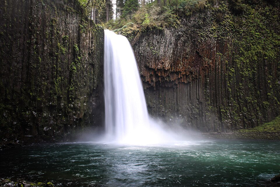
Tucked into the Willamette Valley foothills, Abiqua drops into a near-perfect circular amphitheater of hexagonal basalt columns draped in green moss. It looks like a movie set.
What makes this stop different: Getting there is half the story. A rough dirt road and a short but steep trail keep the casual crowds away, which is exactly why it stays so special. The 92-foot plunge sits dead center in that mossy bowl, and the clear pool at the base is a favorite for a quick, chilly dip. The trail is on private land and can be slick, so tread carefully and pack out everything.
What you need to know before you go:
Location: near Scotts Mills, off a rough forest road
Distance: about 0.8 mile to the falls from the lower parking area, steep coming back
Cost: free, but a high-clearance vehicle helps on the access road
Time needed: 1 to 2 hours plus the slow drive in
Worth it or skip it? Worth it for adventurous hikers who don't mind a bumpy road and a steep climb out.
That basalt amphitheater is worth remembering, so drop it on your bucket list
Shellburg Falls
Just outside the busy gates of Silver Falls State Park, this 100-foot ribbon pours over a basalt lip in the Santiam foothills, and hardly anyone thinks to look for it.
The quick pitch: For years, hikers loved that the trail once ducked into a cave behind the falling water. The area was hit hard by the 2020 Beachie Creek Fire and reopened in 2024 with a revamped trail. The route now leads to a canyon viewpoint of the falls rather than behind it, so check current conditions before counting on that behind-the-curtain angle. The walk along Shellburg Creek, thick with wildflowers in spring, is a treat either way.
What you need to know before you go:
Location: near Mehama, off Highway 22 in the Santiam State Forest
Distance: about 1.6 miles round trip from the lower trailhead
Cost: no fee or permit needed
Time needed: around 1 hour, best in spring or after rain
Worth it or skip it? Worth it if you want a quiet alternative to the Silver Falls crowds without the parking fee.
Keep this quiet Santiam gem on your bucket list for the next Salem trip
Drift Creek Falls
Out in the Coast Range near Lincoln City, the real star sneaks up on you: a long suspension bridge swinging high over a forested canyon, with a 75-foot waterfall dropping right beside it.
Why this one stands out: That 240-foot cable bridge is one of the longest pedestrian suspension bridges in the state, and crossing it puts you eye level with the falls. The walk in winds through a mossy, ferny coastal forest that feels straight out of a fairy tale. It's an easy, well-graded trail, so it works for most of the family, with a mild climb on the way back out. Storm season can leave a few trees across the path, so pick a clearer day.
What you need to know before you go:
Location: Siuslaw National Forest, about 40 minutes east of Lincoln City
Distance: roughly 3 miles round trip
Cost: Northwest Forest Pass or $5 day-use fee
Time needed: 1.5 to 2 hours
Worth it or skip it? Worth it, and one of the most memorable easy hikes on the whole Oregon Coast.
Swaying bridge, big view. Add this one to your bucket list now
Found three you like already? With Wayback Tours you can save every stop and start building your Oregon waterfall bucket list in one place.
Proxy Falls
High along the McKenzie Pass Highway, twin veils of water fan down a mossy cliff, then vanish. There's no stream at the bottom, just water sinking straight into the ground.
Don't skip this if you like a little magic: The easy loop crosses an old lava field colonized by vine maple that lights up gold in fall. The lower falls slip over 200 feet down a broad cliff, and the water disappears into the porous lava rock at the base instead of forming a creek. It's one of the most photographed cascades in Oregon for good reason. Just remember the highway in closes for winter, so this is a warm-season stop.
What you need to know before you go:
Location: Highway 242, Three Sisters Wilderness, near McKenzie Bridge
Distance: about a 1.6-mile loop
Cost: $5 day-use fee or Northwest Forest Pass, plus a free self-issued wilderness permit in season
Time needed: 1 to 1.5 hours; road typically open late June into fall
Worth it or skip it? Worth it, hands down, if the seasonal road is open when you're passing through.
Fun Fact:
Proxy Falls is widely known for its vanishing act. The water sinks into the porous lava at its base instead of running off in a stream.
Catch it before the road closes for winter. Save it to your bucket list
Watson Falls
Down in the North Umpqua canyon, Watson sends a thin, wispy plume off a towering basalt cliff into a green, dripping alcove. It's tall enough to soak you from the viewpoint.
Why it's worth stopping: This is one of the tallest waterfalls in southern Oregon, and the short loop climbs quickly through old-growth forest to a bridge with a head-on view. Push a little farther up the muddy path to the upper viewpoint and you'll feel the full mist and power up close. It pairs perfectly with Toketee Falls just down the road, so you can bag both in an afternoon. This whole stretch of Highway 138 is nicknamed the Highway of Waterfalls for a reason.
What you need to know before you go:
Location: Highway 138, about 60 miles east of Roseburg
Distance: roughly 0.8-mile loop, mostly uphill
Cost: free
Time needed: 30 to 60 minutes
Worth it or skip it? Worth it, especially in spring when snowmelt gives it real force.
One of the tallest around, so park it on your bucket list for spring
Toketee Falls
A short walk down a staircase-heavy trail ends at one of the most striking scenes in the state: a two-tiered fall framed by a wall of columnar basalt, dropping into an aquamarine pool.
Why this one stands out: The shape is the magic here. The water spills over a U-shaped lip of stacked basalt columns, and thanks to an upstream dam it flows steadily all year. The trail runs less than a mile with plenty of stairs and a fenced viewpoint at the end. You'll see photos taken from the base, but that requires a dangerous, eroded scramble, so the view from the platform is the smart call.
What you need to know before you go:
Location: Highway 138, near Toketee-Rigdon Road east of Roseburg
Distance: about 0.8 mile round trip
Cost: free
Time needed: 30 to 45 minutes
Worth it or skip it? Worth it for just about everyone, and a great leg-stretcher on the drive toward Crater Lake.
Fun Fact:
The name Toketee comes from a Chinook trading word widely understood to mean "pretty" or "graceful."
You'll want this postcard view saved, so add it to your bucket list
Golden and Silver Falls
Way back in the coastal hills east of Coos Bay, two big waterfalls hide in one small, quiet state natural area. Most visitors have never heard of it.
The quick pitch: Both falls tumble over 200 feet down sheer rock into mossy, fern-lined bowls, and short, easy trails lead to the base of each. A longer path climbs to the top of Golden Falls along an old cliff-blasted homesteader route with big views. The drive in ends on a narrow gravel road, which is part of what keeps it so peaceful. Spring and after heavy rain are when both really come alive.
What you need to know before you go:
Location: about 24 miles northeast of Coos Bay, past Allegany
Distance: from roughly 1 mile to around 3 miles if you visit both falls and the upper trail
Cost: free
Time needed: a half day, including the slow drive in
Worth it or skip it? Worth it if you want two dramatic falls and near-total solitude in one trip.
Two big falls, one trip. Pin them both to your bucket list
Ready to turn this into a real trip? Line up your favorite falls and map the drive with Wayback Tours before the next long weekend.
Conclusion
Chasing hidden waterfalls in Oregon is one of the best excuses to get off the main highway and into the trees. Some of these you'll earn with a bumpy drive or a steep climb. All of them hand you the kind of quiet that a place like Multnomah Falls just can't offer on a Saturday.
Pick two or three that fit your route, check the road and trail conditions, and go while the water is running strong.
Save these stops, build your own Oregon road trip bucket list, and keep track of every waterfall you want to visit, all in one place with Wayback Tours.
FAQs
Are there hidden waterfalls in Oregon you can see without much hiking?
Yes. Several are short walks or nearly roadside, and you can catch the top of Watson Falls right from its parking lot. Toketee Falls is also a quick trip on a well-built trail.
Do I need a permit or pass for Oregon waterfall trails?
Many national forest trailheads ask for a Northwest Forest Pass or a $5 day-use fee, while some state and county sites are free. Always check the specific site before you drive out.
Are Oregon waterfalls worth visiting in winter?
They can be. Some flow harder and even freeze into ice formations, but mountain roads and trails may be snowy or gated, so confirm conditions before you go.
Which hidden waterfall in Oregon is best with kids?
Toketee Falls and Watson Falls both have short, well-graded trails with fenced viewpoints, which makes them friendly for families with younger hikers.
How many waterfalls does Oregon have?
Oregon is said to have hundreds of named waterfalls, with the exact count varying by source. You could chase new ones for years and still not see them all.


Comments